your question
What are we building?
Our Answer
In addition to creating a naturalized river valley—which, in itself, is a historic and significant undertaking—a crucial part of this project involves building new public spaces, roads and bridges and utilities, as well as structures to control water flow and manage sediment and debris.
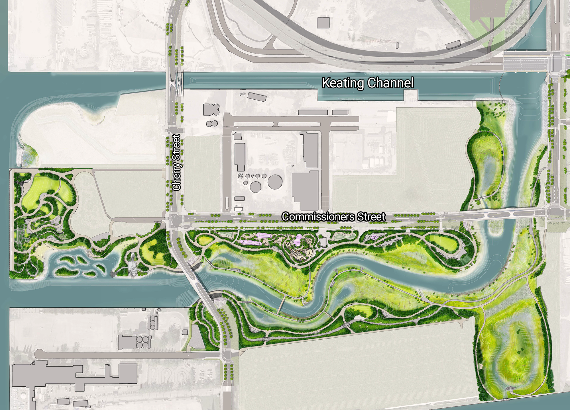
Island
With flood protection complete, the new island is ready to launch. The new river valley created a new island, called Ookwemin Minising (formerly Villiers Island) which is bound by the Keating Channel in the north, the new river to the east and south, and the inner harbour to the west.
A historic gathering place, the Don River will be at the heart of a new community on Ookwemin Minising, soon-to-be home to more than 15,000 people and a destination for all to visit and explore.
Design begins this summer for the fundamentals needed to develop the island, including the public spaces, streets, stormwater and sanitary pipes, and utility ducts that will support the building of new homes and destinations. For more information on how you can get involved in community outreach and public engagement initiatives, check out our Get Involved page.
Parks
In addition to the naturalized area within the new river valley and Don Greenway, the design includes more traditionally programmed parkland. This parkland includes a new park system that runs along the new river, called Biidaasige Park. This new park has been designed to include a variety of spaces, some for activities and some for relaxation. In total, the new park will provide 80 acres of parkland, greenspace and new river access.
Biidaasige Park will open in two phases to allow for immediate access to public greenspace and the water. The first 50 acres opened in July 2025, and the remaining 10 acres of park will open in 2026.
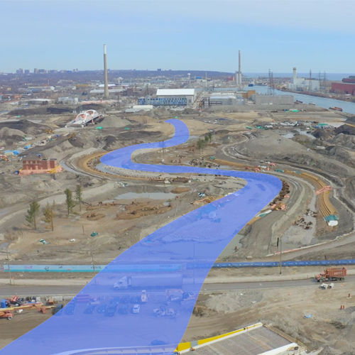
Earthworks/Flood Protection
To support the new development, earthworks and vital flood protection was completed to support new critical infrastructure and community development.
Cherry Street Stormwater and Lakefilling
Lakefilling around Essroc Quay was done to support the realignment of Cherry Street and create the foundation for the northwest corner of the island. In the future, this space is planned to become the continuation of Biidaasige Park. We also created coves along the new shoreline where fish can find food and shelter and small boats can launch.
As part of this project, we built wetlands, aquatic habitat and natural coastline features. To increase the aquatic diversity in the area, we established a habitat where fish like to live by growing plants they like to eat. It is the only natural shoreline in Toronto’s Inner Harbour.
Construction started on Cherry Street Lakefilling in winter 2017 and was completed in March 2020.
Cherry Street Stormwater and Lakefilling
Lakefilling around Essroc Quay was done to support the realignment of Cherry Street and create the foundation for Promontory Park. This became the northwest corner of the new island. We also created coves along the new shoreline where fish can find food and shelter and small boats can launch.
As part of this project, we built wetlands, aquatic habitat and natural coastline features. To increase the aquatic diversity in the area, we established a habitat where fish like to live by growing plants they like to eat. It is the only natural shoreline in Toronto’s Inner Harbour.
Construction started on Cherry Street Lakefilling in winter 2017 was completed in March 2020.
Polson Slip Naturalization
This area is on the north side of the Polson Slip.
The north side of Polson Slip will become part of the naturalized river valley. The wall of the slip was reinforced so that it can withstand fast-flowing waters during a major storm.
River Valley Naturalization Area
This area is the new river that flows between the Keating Channel and Polson Slip and surrounding wetlands.
We’ve created a new one kilometre river valley as a new outlet through which the Don River can flow. The banks of this river valley are reinforced to withstand fast-flowing waters during a major storm. A naturalized river mouth is now part of a renewed ecological system of coastal wetlands and meadows.
Don Greenway (Spillway & Wetland)
This area is on the northwest corner of where the Don River meets the Keating Channel, north of Lake Shore Boulevard and south of Corktown Common.
Sediment and debris need to be removed regularly from the Don River to keep water flowing safely through the river valley, reduce the impact of flooding and maintain safe navigation in the inner harbour. Currently, Ports Toronto dredges mud, silt and larger debris from the Keating Channel. To allow water to flow under the Lake Shore Bridge during a major flood, we have widened and deepened the Don River upstream of this bridge. This has slowed down the water, releasing more sand and silt onto the river bed. To address this, we are moving dredging operations and debris management north of Lake Shore.
Sediment and Debris Management Area
This area is on the northwest corner of where the Don River meets the Keating Channel, north of Lake Shore Boulevard and south of Corktown Common.
Sediment and debris need to be removed regularly from the Don River to keep water flowing safely through the river valley, reduce the impact of flooding and maintain safe navigation in the inner harbour. Currently, Ports Toronto dredges mud, silt and larger debris from the Keating Channel. To allow water to flow under the Lake Shore Bridge during a major flood, we need to widen and deepen the Don River upstream of this bridge. This will slow down the water, releasing more sand and silt onto the river bed. To address this, we are moving dredging operations and debris management north of Lake Shore.
Island Grading
This area is the middle of the new island, in the area that is not set to become new parks.
To flood protect the Port Lands, the majority of land within the Don River’s floodplain was raised. As part of this project, we’ve designed grading for all sites in the area, including the new island. As development progresses in the Port Lands, it will be the future developers’ responsibility to re-grade their individual sites.
Bridges and Structures
Cherry Street Bridge North
This bridge is on the newly aligned Cherry Street, across the Keating Channel. There are two new bridges at this location, one of which will be dedicated to Light Rail Transit (LRT) in the future. The other carries vehicles, cyclists, and pedestrians.
Cherry Street Bridge South
This bridge is on Cherry Street between Polson Street and Commissioners Street, over what was the Polson Slip and now serves as the new mouth of the Don River. We designed this bridge to accommodate the higher, faster waters expected to flow beneath it during a major storm.
Commissioners Street Bridge
This bridge is on Commissioners Street between Don Roadway and Munition Street, across the new river valley. We designed this bridge to accommodate the higher, faster waters expected to flow beneath it during a major storm. The sidewalk also features some wider areas meant to provide a lookout over the new river valley.
Lake Shore Boulevard East Bridge over the Don River
The existing bridge at Lake Shore Boulevard and Don Roadway and the adjacent rail bridge act as a pinch point. This restricts the flow of water, increasing flood risks. By extending the Lake Shore Bridge at its west end, we have created a wider opening over the Keating Channel, allowing higher, faster water to flow safely through the channel during major storms. This work has been combined with the City of Toronto’s Gardiner East project, into what we’ve called the Lake Shore Boulevard East Project.
Roads and Municipal Infrastructure
Site-Wide Municipal Infrastructure
We created new systems and extended existing systems. This includes utilities like hydro, lighting, gas and telecommunications. A new water distribution network will connect future communities to the existing municipal water mains. A new municipal sanitary sewer network and pumping station will carry wastewater from future communities to the Ashbridges Bay treatment facility. And a new stormwater system will manage rainwater during major storms.
Don Roadway
Don Roadway is north/south street on the east side of the Don River. It runs south of Lake Shore Boulevard to Commissioners Street. We’re rebuilding the Don Roadway between Commissioners Street and Lake Shore Boulevard at a higher elevation to protect the lands east of the road from flooding during a major storm. The new road will include two vehicular travel lanes and sidewalks on each side.
Cherry Street Realignment
The new Cherry Street alignment continues directly south from Cherry Street north of Lake Shore Boulevard (rather than its former location further east). The new Cherry Street includes sidewalks, a multi-use trail, a future dedicated transit lane and two lanes of vehicular traffic. It was built approximately 50 metres west of the old Cherry Street to preserve the heritage structures located on either side of the old street. The old Cherry Street alignment has been renamed Ookwemin Street.
Commissioners Street
Commissioners Street is the main east-west road on the island, starting at the new alignment of Cherry Street and continuing east. Commissioners Street was maintained in its original alignment but widened to accommodate dedicated transit and cycling lanes. In addition to a sidewalk on the north side, we built a pedestrian pathway along the southern side of the street, which borders the northern edge of River Park.

Video
Aerial view of the transforming Port Lands
See the latest drone footage of the construction site.
Watch video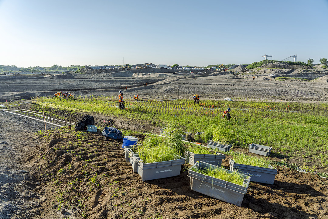
Article
Planting in the Port Lands
While we’re planting in the Port Lands, 18,00 – 22,000 plants will be delivered weekly. Here’s how we’re getting so many plants into the ground.
Read more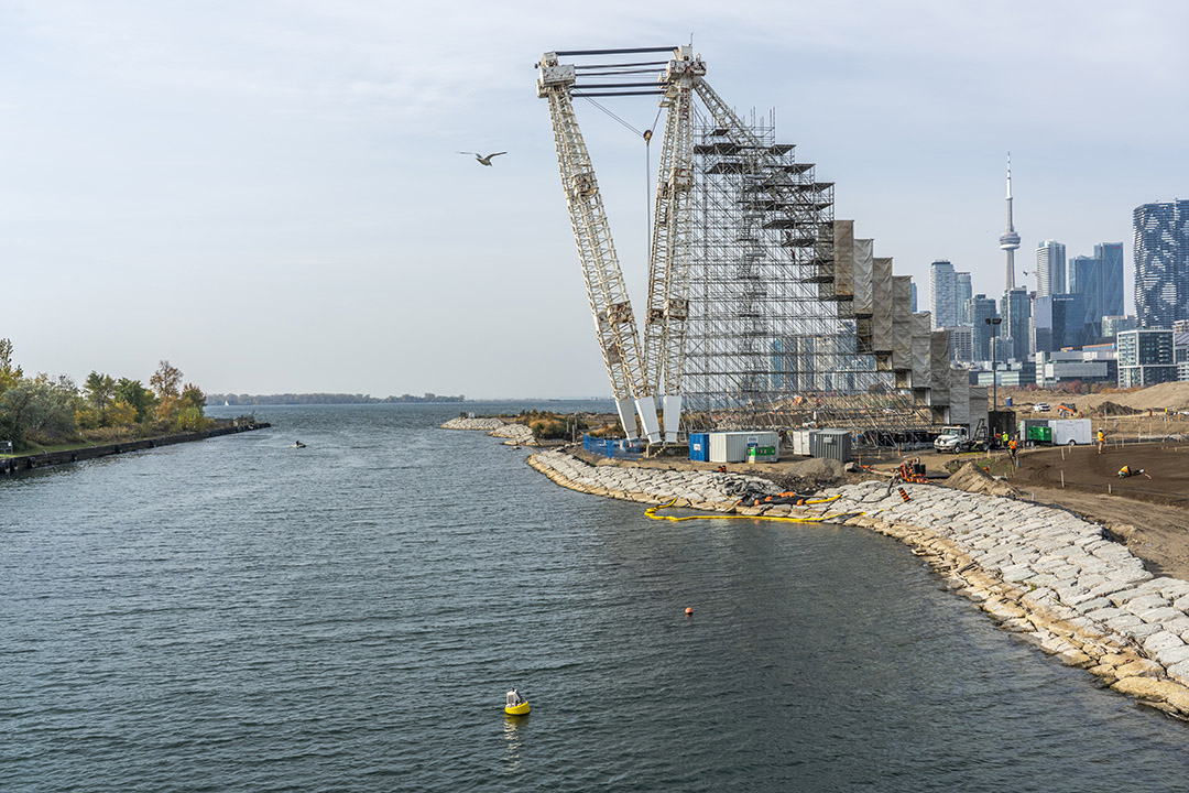
Blog
Industrial Heritage
The 300-ton Atlas Crane stands tall over the new island, recently named Ookwemin Minising, in Toronto’s Port Lands.
Read more